In 2024, OpenStreetMap experienced its largest recorded increase in pedestrian mapping, including footways and crossings. Across the top 10 U.S. cities, contributors added 9,896 km of footways and 62,153 individual crossings.
As with past trends in OpenStreetMap, most edits were made by a small but dedicated group of contributors. I wanted to understand why certain cities have better data than others and identify which variables are contributing to the increases. Here is a look into the data and a few of the most impactful efforts underway contributing to the increase.
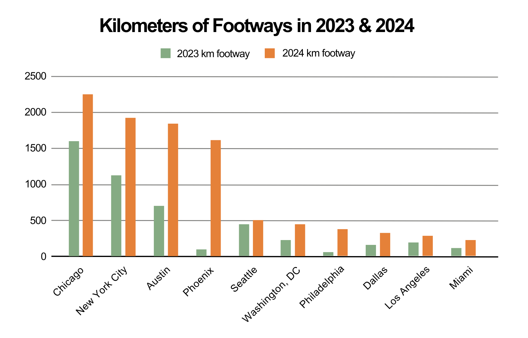
Footways | 2023 vs. 2024
The chart below compares footway edits over time in 10 US cities. Every city saw an increase, with Austin, Phoenix, Washington, Philadelphia, Dallas, and Miami growing over 50%. These gains will be hard to sustain year over year as sidewalk networks become more complete, but don’t worry, there is still plenty of mapping to do!
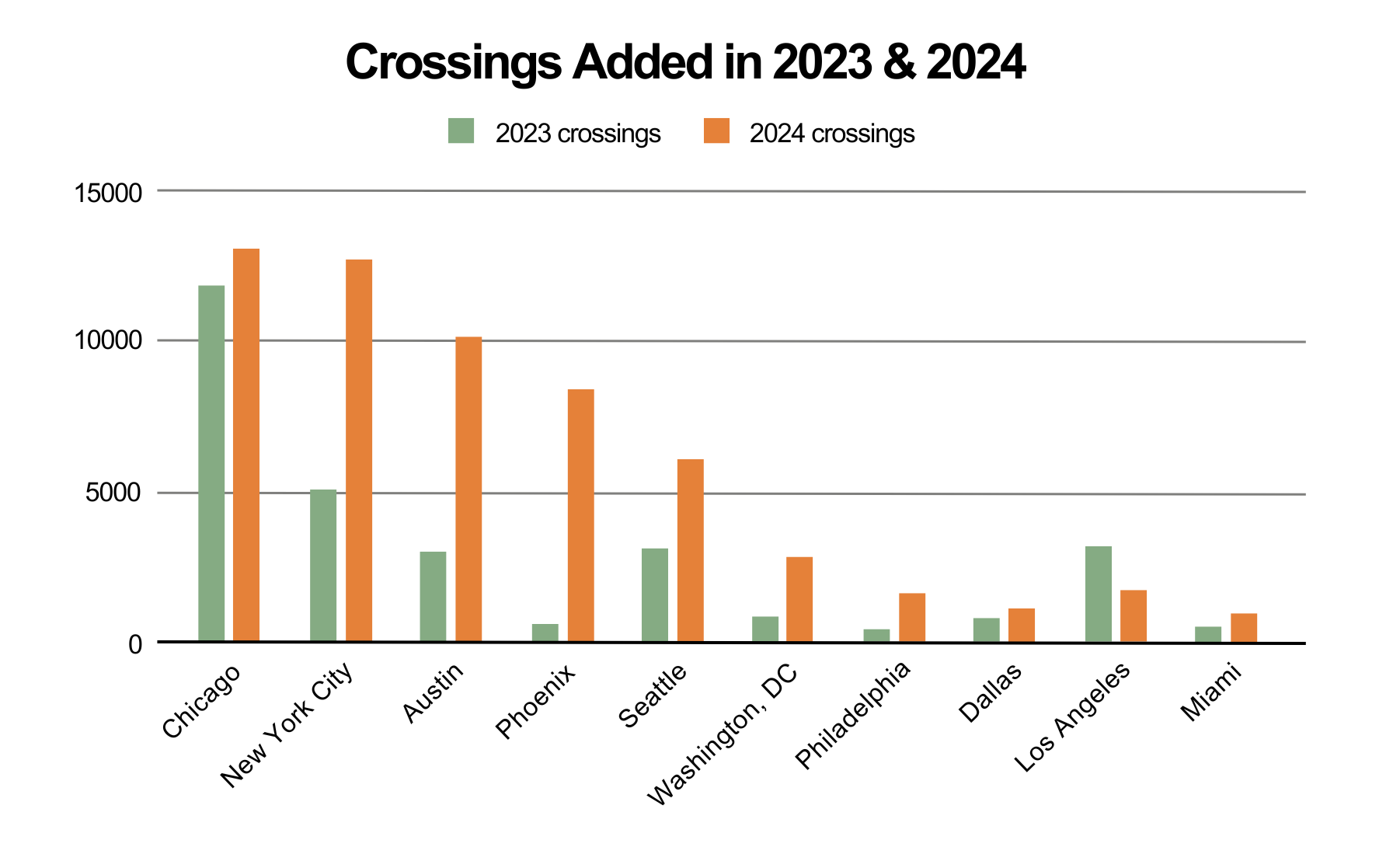
Crossings | 2023 vs. 2024
We see a similar trend with crossings in every city except Los Angeles. Crossings are super important to pedestrian safety and navigation while being particularly difficult and time consuming to map. Crossings often require local knowledge or recent street images to identify tags such as markings, signals, and curbs.
Unmarked crossings are a big challenge to mappers but critical for routability. Local laws dictate how pedestrians can cross at unmarked locations, which makes it difficult to establish consistency within OSM.
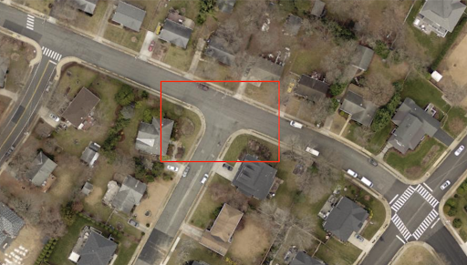
This example shows an unmarked crossing in an area with marked crossings. Unmarked crossings are important for routability and must be added judiciously while considering pedestrian safety.
As we look at increasing trends and the rate at which pedestrian data are being generated, below are a few focused efforts underway to improve pedestrian data.
Pedestrian Working Group
On March 5th, 2024, OSM US launched the Pedestrian Working Group (PWG). After working with the community and witnessing different styles of mapping pedestrian data it became evident we needed better guidance to build data fit for purpose. Over the past year the PWG conducted a survey identifying core requirements and designed a draft tiered schema that calls for differing levels of detail based on the intended use case. The PWG is currently soliciting feedback on the schema and identifying partnership opportunities with individuals and organizations committed to improving pedestrian safety with data. Sign up to join the PWG and contribute to making this concept a reality.
Super Mappers
In February of last year I met mycota (Sean), a Environmental Science professor from Arizona dedicated to improving pedestrian data. He mapped a big portion of downtown Phoenix and his individual contributions accounted for 20% of the footways and 15% of the crosswalks added last year. Go Sean!
After meeting Sean I came across more Super Mappers who reside in cities where they map. These mappers are a tremendous resource as they understand local pedestrian regulations, understand areas of need, and perform quality checks to improve data consistency. New York City has a core group of mappers who do a great job with quality monitoring.
Last September kaleidoscopica from Austin Texas posted the message below on Slack. I looked into the numbers and kaleidoscopica was responsible for contributing 1,682 km out of the 1,854 km of footways added in 2024, that’s 90%!

The Walkabout
In the Fall of 2023 Meta launched The Walkabout Initiative, hosting mapathons, webinars, and collaborating with organizations and local mappers to build routable networks in major cities. They had projects in 5 of the top 10 cities focusing on the densest downtown areas. Projects were managed through the Tasking Manager, and Map Roulette used to surface Machine Learning outputs to validate and add missing features. Check out the latest release of Rapid for new “pedestrian friendly” editor improvements.
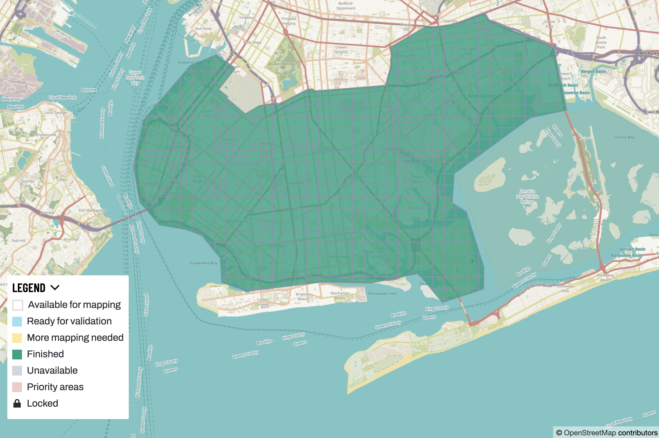
Walkabout project area that covered all of Brooklyn, NY and took about 9 months to complete. The local community played a big role in mapping and validation.
YouthMappers
Through the Walkabout initiative, YouthMappers and Meta launched a paid internship program with students from George Washington University. The idea was to provide students with practical workforce experience by learning how to map pedestrian features, and supporting community mappers with the heavy lifting associated with adding separate geometry. Since the program launched students have completed 12 Walkabout projects adding 4,396 km of footways – that’s 56% of the total contributions in 2024 for the top cities.
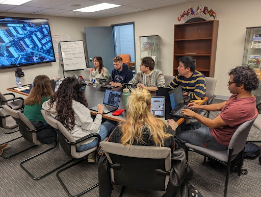
Internship kickoff meeting at George Washington University, April 2024.
Organizational Efforts
In addition to the efforts listed above, I’d like to mention the great work from a number of organizations I’ve coordinated with over the past year who are taking an active role in the quest for better data.
Taskar Center for Accessible Technology: Seattle has some of the highest quality data in the US, thanks in part to a multiyear effort by the Taskar Center who have been hard at work building accessmap, a highly customizable pedestrian navigation map. They are currently expanding coverage of accessmap with data generated through Machine Learning.
Vision Zero: Over the past decade several US cities have adopted the goal of eliminating all pedestrian related fatalities. Cities are forming committees, states are passing legislation, and federal dollars are funneling down to support local initiatives and data generation.
NC-BPAID: National Collaboration on Bicycle, Pedestrian and Accessibility Infrastructure Data was launched in 2023 as a collaborative that aims to develop geospatial data specifications related to bicycle, pedestrian, and accessibility infrastructure in the United States. The goal is to enable the coordination and sharing of data on a national scale.
Get Involved!
We have a long way to go to make pedestrian data complete and usable in cities and towns across America. This is a tremendous effort, and we need more mappers, organizations, and governments to get involved to make OSM the best source for pedestrian infrastructure data available. Here are a few actions you can take now to move this initiative along.
- We need more mappers! Pedestrian data is tedious and time consuming to map but fun once you get past the learning curve. Search “pedestrian” on the OSM US Tasking Manager to find a list of projects. You can also check Map Roulette or use tools like Street Complete to make it easy to improve tags from the field.
- Having recent satellite or aerial imagery is essential. Many major US cities have access to 3”- 6” aerial that’s compatible for editing OSM. There are sources out there currently not being used. Please help us identify those sources so they can be included by default into editors.
- The same goes with Street-level Imagery (SLI), which is critical for accurate mapping. Tools like Mapillary make it easy to contribute SLI, and are integrated with most OSM editors.
- Open pedestrian infrastructure data provided by governments can help improve OSM provided compatible licensing. Open datasets are used to validate features like crosswalks and curbs, and geometries can be added with Rapid.
- If you have or know of any open pedestrian datasets please reach out to me, someone in the Pedestrian Working Group, or post in the OSM US Slack sidewalks channel. From there we can review the data license and identify ways it can be used to improve OSM.
If you like mapping I’d encourage you to take a look at pedestrian data where you live and consider attending State of the Map US 2025 this June in Boston, MA. The theme is “Charting the Course” and there will be plenty of talks highlighting the successes and challenges of accessible and multimodal transportation. I’d like to thank all the great folks I’ve worked with over the past year, especially mappers and members of the PWG who are committed to making OSM the best single source of geospatial data on earth.
Do you have a project, mapping campaign, event, or story worthy of a guest blog post? The OSM US team invites you to check out the guest post guidelines, and reach out to team@openstreetmap.us with your idea. We’d love to feature you!