Bridging the open data gap
Public Domain Map is a bridge database that lets organizations crowdsource authoritative map data in cases where OpenStreetMap isn’t an option. Mappers can address public data gaps while producing high quality data that is format- and license-compatible with OSM.
Public Domain Map (PDMap) is a project of OpenStreetMap US that allows map contributors across the United States to edit, contribute to, and consume federal datasets via a collaborative user environment and modified versions of popular OpenStreetMap tools; simultaneously improving government datasets and OpenStreetMap.
US Government agencies are increasingly realizing the value of crowdsourcing open data. Through Public Domain Map, government agencies can access the power of the crowd to improve government datasets and contribute validated data to OpenStreetMap.
“Many government agencies and private companies are unwilling to accept the legal risk of using data not explicitly placed in the public domain. Removing these restrictions fosters data sharing, the creation of knowledge, and cultivates understanding.”
, Transportation Theme Lead, NSDI, USDOT
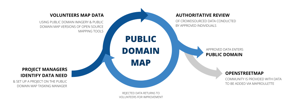
The toolstack includes a custom version of the iD Editor embedded in the OpenStreetMap US Tasking Manager. The OpenStreetMap database will then be improved with this authoritative data via tools such as MapRoulette.
All contributions remain in the public domain, which allows the original government public domain datasets to accept edits from users and allows the edits to be applied to OpenStreetMap.
Interested in using Public Domain Map for your agency? Reach out to info@publicdomainmap.org.
