For the past two months, OpenStreetMap US has featured short interviews with OSM contributors in our newsletter. We received so many interesting stories that we decided to expand the highlights into a blog series, to allow for more details about the mappers and mapping groups featured. For the first in this new blog series, enjoy an interview with Jacob Hall and Daniel Schep of MapRVA, Richmond, Virginia’s local mapping group!
Give a brief history of MapRVA.
After a bunch of Richmond-based mappers met each other at the State of the Map US conference in 2023, I think there was some interest in meeting up. A few months later a community member named Robert reached out on the OSMUS Slack to see if anyone was interested in an RVA meetup. A few of us agreed, and MapRVA has grown ever since!
We’ve had some regulars show up for most meetings, and others come and go. Our membership has generally increased since we started, especially after we published a map of the famed Richmond Water Crisis. We represent a wide range of mapping interests including:
- Bike and pedestrian infrastructure
- Security cameras and ALPRs
- Mapping schools, especially college campuses
- Food pantries around Richmond
- …and much more!
Some of our members are long-time OpenStreetMap contributors, others are local GIS professionals or academics. We welcome anyone, regardless of their experience level, to join in the fun and learn about mapping with us.
“My favorite thing about being a part of MapRVA is learning about all kinds of neat mapping projects outside of my usual areas of interest. School mascots, waterways, pirate bike trails, street name etymology, OpenHistoricalMap, MapRoulette - every meeting brings new collaborations and ideas. 😊”
What do MapRVA meetups usually look like?
We try to strike a balance between informal meetups at breweries or restaurants, and more work-oriented meetups where people bring their laptops and get some OpenStreetMap edits in. The latter usually happens at libraries or even one of our homes. More recently we’ve held some virtual “Map & Yap” Zoom calls, which have been great for connecting with community members who might not make it in-person.
Sometimes our meetups are just two people, one time it was over a dozen! We sometimes come to a meeting with a specific task to work on together, e.g. a Maproulette challenge. Other times we just catch up, and hear about the different projects folks are working on!
“My favorite thing about MapRVA is meeting some way cool people and, as a lifelong map lover, being able to scratch my nerd itch with friends. We’re a ragtag group that can make a big impact, as seen by the water crisis map!”
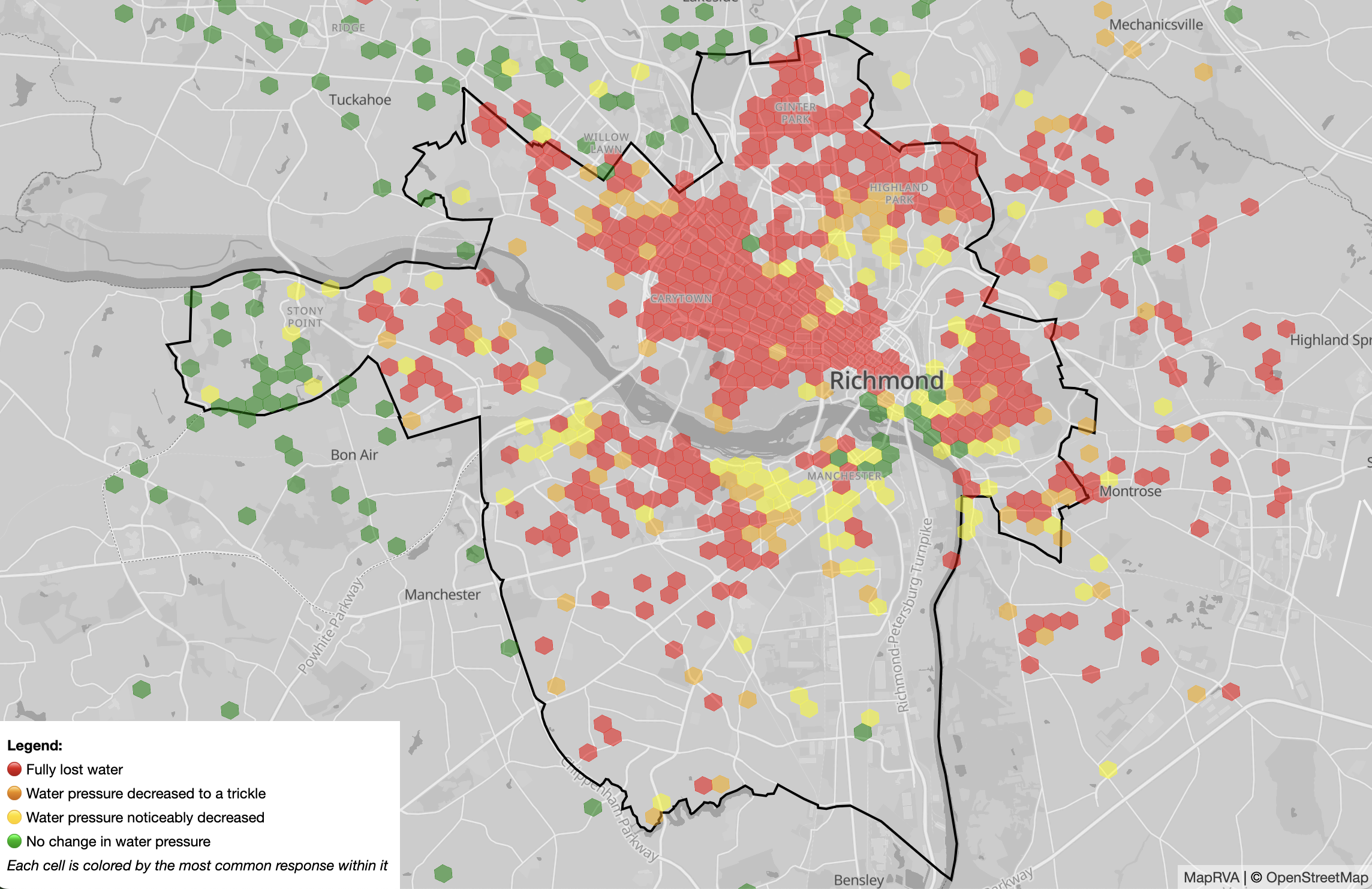
The Water Crisis? What was that about?
In January 2025, Richmond experienced a week-long water crisis, during which our city lost water service. It was a confusing time, with little communication from the government about the extent of the outage. MapRVA cobbled together an online survey asking residents to report if they had water at home. We published a map on our website visualizing this data, which caught the attention of local news outlets including our local NPR station (image below).
Come see our talk “How we Mapped the Richmond Water Crisis” at State of the Map US in June to hear the whole story!
Tell us more about the projects folks in MapRVA are working on!
A big focus for us is mapping bicycle and pedestrian infrastructure in Richmond. We host discussions of how to best tag these features in our city, and then work together to keep the relevant OpenStreetMap elements up-to-date. Sometimes this involves a Tasking Manager project to add sidewalks, or a Maproulette challenge to assure the quality of bike lanes. We also maintain OSMCha filters for relevant tags so that we can keep an eye on new contributions.
We are also creating thematic maps for subjects like surveillance apparatuses and community fridges/pantries, powered by OpenStreetMap. These maps are built using Ultra (developed by our very own Daniel Schep!), which enables us to rapidly iterate on both the map data and cartographic styling. Our goal is to make contributing to these maps easier for Richmonders, so that more folks can help map the things they care about.
“Similar to others, my favorite thing about MapRVA is being surrounded by people who are curious. People have different things they may be interested in, but are always excited to see (literally and figuratively) what else is out there.”
Any advice for mappers looking to start meetups in their area?
- The OpenStreetMap US Slack has been a great place to organize. We also reached out to some active editors directly, which was a surprisingly effective recruitment strategy! (Shout-out to Meet Your Mappers, a tool designed for this purpose!)
- Meetups can be simple. Meeting at libraries or other public spaces is usually free, and accessible to anyone. Get a friend to join you, and advertise your meetup in online OSM spaces.
- Follow your own interests. Contributing to and discussing local map data that you care about will attract like-minded folks. It’s ok to chip away at different projects, pass them around the group…remember to have fun!
Editor’s note: OpenStreetMap US also has a microgrant to fund mapping meetups in the United States!
How can I get involved in MapRVA?
- Join the #local-rva channel on the OpenStreetMap US Slack to chat with us
- Follow our fediverse account for meetup and project announcements
- To read more about our work, check out our website!
Thank you for Daniel Schep, Jacob Hall, Kevin Finity, Mike O’Brien, Evan Robohm, and all of the members of MapRVA for their time and insight! Do you know a mapper or mapping group worthy of a highlight? Reach out to newsletter@openstreetmap.us.