The 12 Months of OpenStreetMap is an initiative led by OpenStreetMap US, and inspired by the Project of the Month done by map contributors in France, Switzerland, and Germany. The initiative is designed to engage the mapping community and volunteers around a new theme every month.
Quality and access to water can vary dramatically in the United States. Understanding where our drinking water comes from, where access is available, and where contamination may occur can help close gaps in access and quality. As August is National Water Quality Month, we’re focusing this month on mapping for improved water quality and access.
What you can map
Use this brief guide to get started and what resources to use. Be sure to add #12MonthsofOSM to your changesets in August.
1. Mapping public water and sanitation access in your neighborhood
More than 2 million Americans live without basic access to safe drinking water and sanitation, including half a million people experiencing homelessness. Systematic closing of facilities and deprioritization of development have been exacerbated by COVID-19 measures. To understand access issues in your area, map public water and sanitation features.
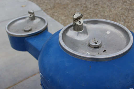
For drinking water points, use the tag amenity=drinking_water, add bottle=yes if it is a station designed for refilling water bottles. More information can be found on the OSM Wiki here.
Map public toilets using the amenity=toilets tag. Add critical tags such as wheelchair=* and opening_hours=*. More information can be found on the OSM Wiki here.
You can add drinking fountains to OpenStreetMap via MapComplete:
2. Mapping stormwater management features in your area
Stormwater runoff, generated from rain or snow flowing over impervious surfaces such as paved streets, is a major contributor to freshwater pollution. Map features that contribute to stormwater management, in particular, features that are designed to reduce runoff pollution from directly entering freshwater bodies:
-
Storm drains are the main intake feature for stormwater runoff. Map these features with man_made=manhole + manhole=drain. Read the OSM wiki for further instructions. After mapping, consider adopting your nearest drain if your city has a program, like the Grand Rapids Adopt-A-Drain program.
-
Rain gardens & drain basins are designed to filter contaminants from stormwater runoff before it enters the water system, typically placed along roadsides and in parking areas. Map these rain gardens and drain basins with landuse=basin + basin=infiltration. More information can be found on the OSM Wiki here
-
Green roofs not only reduce stormwater runoff but also reduce the impacts of urban heat island effect. Add roof:material=grass to buildings in your city with green roofs. (Note: roof:material=grass is used for all green roofs, regardless of plant type.) Be sure to check out Roofpedia, an open registry of sustainable roofscapes around the world that incorporates OpenStreetMap building footprint data, developed by Abraham Noah Wu at the Urban Analytics Lab, National University of Singapore, Singapore. While the solar and green roof data itself was derived from AI models & satellite imagery, this is a great example of analysis that could be done if green roofs and other sustainable infrastructure are mapped.
Above: Roofpedia data for New York City highlighting structures with green roofs (green) and solar installations (yellow). Map via Roofpedia.
3. Mapping water sources
Do you know where your drinking water comes from and is stored? Depending on the hydrology of your area and the population density, your drinking water may come from a reservoir or directly from a source such as groundwater or a river system.
To map water storage features such as reservoirs, tanks, and ponds, review the OSM wiki page here. For mapping bodies of water, use natural=water and the appropriate additional tags. For springs, use natural=spring.
Remember to include #12MonthsofOSM in all your changesets.
Monthly Project
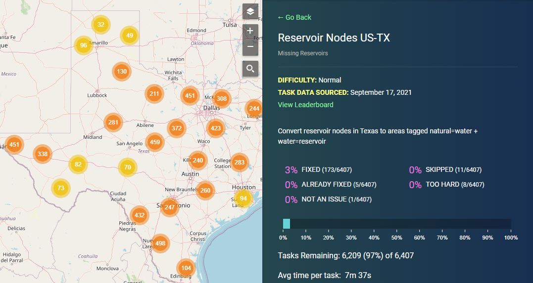
Each month in 2022, we’ll highlight (or set up) a project for the OpenStreetMap US community to gather around and map. This month, help us finish Missing Reservoir projects in MapRoulette, select your state or region to complete.
Are we missing any great resources, recommendations or tips on mapping the water resources? Email us at team@openstreetmap.us and we’ll do our best to add your expertise here.