The 12 Months of OpenStreetMap is an initiative led by OpenStreetMap US, and inspired by the Project of the Month done by map contributors in France, Switzerland, and Germany. The initiative is designed to engage the mapping community and volunteers around a new theme every month.
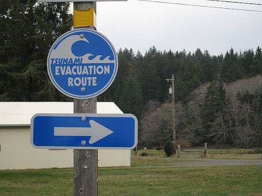
From local responders to federal agencies, OpenStreetMap is being used as a data source, direct basemap or indirectly through map services such as Mapbox and ESRI in emergency responses and preparedness in the US. The Federal Emergency Management Agency (FEMA) lists OpenStreetMap as the most up-to-date building and road network dataset following disasters in its Crowdsourcing Toolkit for emergency managers. Meanwhile, firefighters rely on the data to plan and engage in wildfire responses. The OpenStreetMap community plays an important role in keeping the map up to date to ensure that those relying on OpenStreetMap data can know where people and resources are in times of emergency.
As many families and individuals build or restock their emergency kits during September as part of National Emergency Preparedness month, we’re encouraging mappers to add OpenStreetMap to the checklist of ways to prepare globally and locally to emergencies. This month, contribute to OpenStreetMap to help improve the availability of data that planners and responders use to reduce the impact of local emergencies and disasters.
Check out this presentation from Rob Savoye at State of the Map US 2022 on how OpenStreetMap supports firefighters:
What you can map
Use this brief guide to get started and what resources to use. Be sure to add #12MonthsofOSM to your changesets in September.
1. Map fire stations in your town or city
There are nearly 30,000 fire stations in the United States (2018) but less than 17,000 are mapped in OpenStreetMap. Knowing where emergency services exist can help identify where services are not available - which is particularly important for underprivileged neighborhoods.
To map fire stations, trace the building (if it is not already mapped) and add the tag amenity=fire_station. Add the Station Name (i.e. “Fulton Street Station”) with name=, and the Department (i.e. “San Diego Fire Department”) with operation= tags. More information can be found on the OSM Wiki here.
Tip: Many fire departments list their stations on their website. Use this information to verify data and ensure completeness for your area.
Are all the fire stations mapped your city? Listen to this video on what OpenStreetMap data is helpful for fire departments:
2. Map hazardous features in your area
Walk around your neighborhood and consider what could become a hazard in the event of an earthquake, tornado, or another disaster. Mapping these locations not only help you prepare, but ensure that they are on the map for others that rely on OpenStreetMap.
Suggested mapping includes:
-
Map industrial zones by tracing the boundary and adding the tag landuse=industrial. Additionally, include industrial=* to denote the type of industry (i.e. oil). More information can be found on the OSM Wiki here.
-
Add gas stations to OpenStreetMap using the amenity=fuel tag. More information can be found on the OSM Wiki here.
3. Mapping buildings in your local area or neighborhood
Is the basemap (buildings and roads) in your neighborhood mapped and up to date? Just like refreshing the food supplies in your emergency go-bag, consider the OpenStreetMap data for your neighborhood as an important resource to monitor and refresh.
If all the buildings are completely mapped in your local area, look for a nearby neighborhood that is incomplete. Consider focusing on under-served neighborhoods in your city.
To map buildings, trace the outline of the building footprint as close to the building edges as feasible. Tag the area feature with building=yes. Always use the building=yes tag UNLESS you can verify through local knowledge that the building is something more specific such as a school or fire station. More information can be found on the OSM Wiki here.
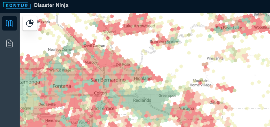
Tip: Not sure if your neighborhood building data is out of date? Check out the “Antiquity” layer on the disaster.ninja app or other layers such as building completeness.
Remember to include #12MonthsofOSM in all your changesets.
Monthly Project
Each month in 2022, we’ll highlight (or set up) a project for the OpenStreetMap US community to gather around and map. This month, we have two! Help us continue mapping buildings in Ocean County, New Jersey for flood resiliency or map buildings in Valley Center, California facing wildfire risk.
Open Imagery Mapping Hour
DK Benjamin joined us for Mappy Hour on September 28 to discuss the open imagery pipeline. DK shared how open imagery tools, such as OpenAerialMap and OpenDroneMap, contribute to the mapping pipeline in OpenStreetMap, and in particular, how open imagery has improved mapping for disaster response. Check out the recording here:
Are we missing any great resources, recommendations or tips on mapping for emergency preparedness? Email us at team@openstreetmap.us and we’ll do our best to add your expertise here.