
Browsing through openhistoricalmap.org is a personal tour of passion projects, obsessions, and areas of awe-inspiring expertise. The area of the map you’re looking at may appear sparse, save for a few boundaries, city names, and railways, until the entirety of New Orleans as it existed in 1885 appears on your screen, down to each saloon, stable, and wagon shed (that’s all thanks to Peter Zivkov and the 1885 Sanborn Insurance Map of New Orleans). Right now, OpenHistoricalMap is raising funds to improve the contributor and data user experience, so for this Mapper Highlight feature let’s dive deeper into notable OHM projects and celebrate the fantastic work of their volunteer community.
This is going to be a long one – there are a lot of neat stories to tell!
Dan Vanderkam is mapping Colombian Departments
Give a brief history of your involvement in OpenHistoricalMap - what got you interested in the project?
I’ve always been interested in history and maps. I first released a project in this space back in 2011. That was OldSF, a historic photo viewer/map mashup that helped you find San Francisco Public Library photos in your area (you can read more about it on its About page.) This was followed a few years later by OldNYC, a similar collaboration with the New York Public Library.
The success of those projects got me thinking bigger: instead of just photos, wouldn’t it be great to have a historical map of everything? I soon learned I wasn’t the only one thinking about this… Fast forward to 2026, and I was looking for a new project. I saw that OHM had grown considerably, and I decided, at long last, to dig in my heels and start mapping.
Provide an overview of your project mapping Colombian departments.
In my boundary viewer, I noticed that many parts of the world were lacking admin_level=4 features (states or provinces). The gaps were particularly striking in Africa and South America. I’d been looking for a “starter project” to get me mapping, and this seemed like a good one. I chose Colombia because I’ve traveled to it several times and my wife has family there.
Editor’s note: To learn more about Dan’s project, check out his detailed post on the OHM Community Forum.
Explain your process of finding and evaluating primary sources for this project. Did you come across any challenges when looking for sources across a vast period of time?
At first, I assumed that I could import administrative boundaries for the present directly from OSM. But the two projects have different licenses, so that was a no-go. Instead, I started with Natural Earth Data, which is CC0. I wrote a script to convert their Shapefile into an OSM PBF file in just the way I wanted (or, rather, I had Claude write me a script!).
Then I imported this into JOSM and began the tedious process of replacing my new borders with existing ways (or parts of ways). There were many of these since OHM already contained rivers, coastlines, and national boundaries. Another user has mapped many admin_level=4 features in South America from the 18th and 19th centuries, so I tried to reuse those ways where I could.
Finding good sources for the ways that Colombian departments changed over time was challenging. Wikipedia has maps, but they don’t cite their sources, and their licensing isn’t compatible with OHM. Not surprisingly, Spanish Wikipedia has more information about historical Colombian departments. In particular, their timeline page was valuable. To trace the changes over time, I’d use that as a guide to original sources, and the Wikipedia maps as a way to check whether I’d missed anything.
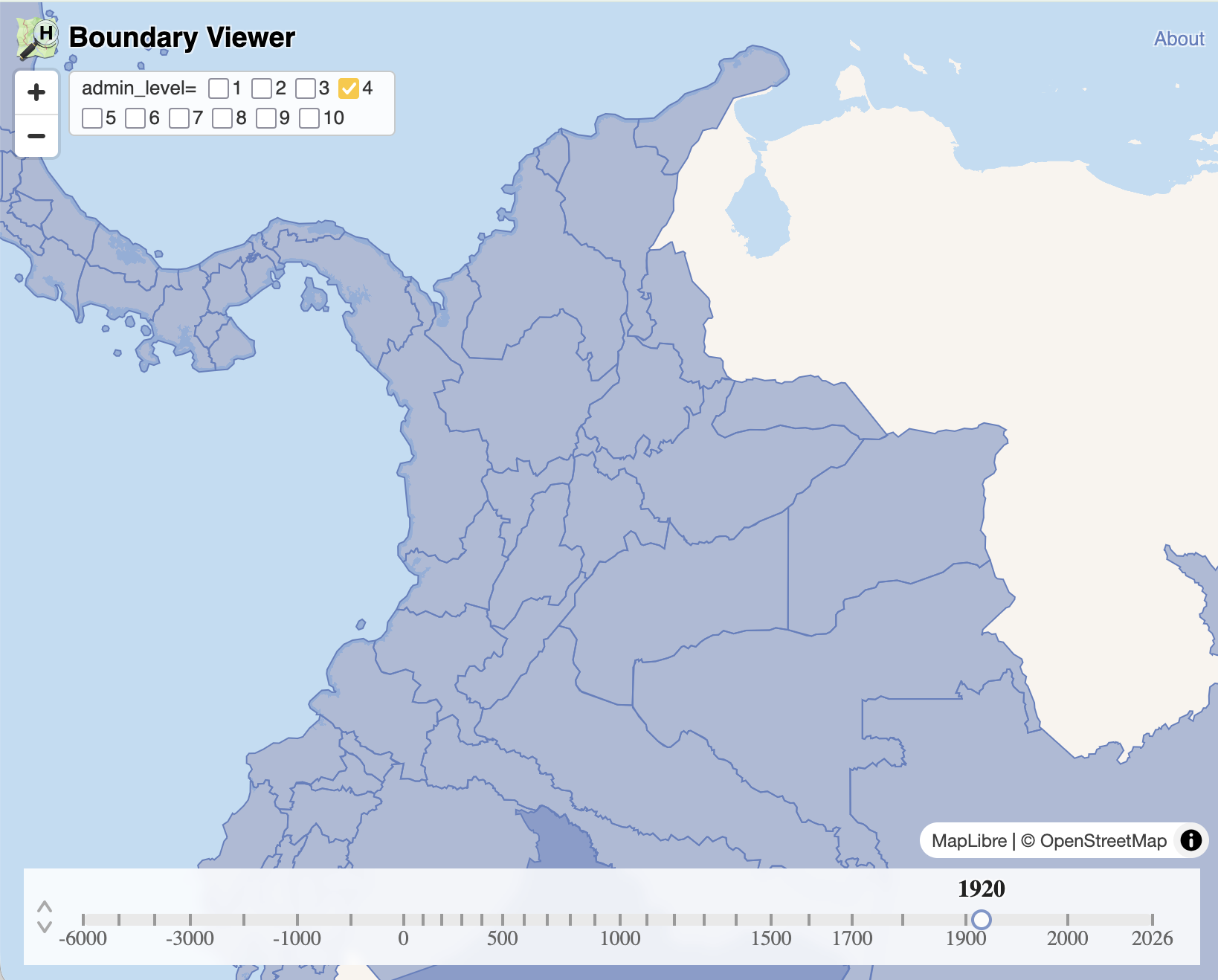
Dan’s OHM Boundary Viewer, which he used to keep track of progress
You mentioned in your forum post wanting to take on this project in part to learn more about using JOSM. What was a helpful tip you encountered along the way?
This project was a great introduction to JOSM. It’s an intimidating program with a learning curve and lots of annoyances. But map editing is not simple, and JOSM is one of the best ways to do it. It’s well worth learning. I know I’ve barely scratched the surface with JOSM, but here were a few highlights:
-
You can add a filter for “type:node” to select ways, and not the nodes along the ways, which was almost always what I wanted.
-
Run JOSM’s Validation tool early and often. It’s a great way to tell if you’ve broken something. It’s helpful to run it before you change anything, so that you know what’s “pre-broken.” Make sure you download parent relations so that you don’t break them when you split a way.
-
If you copy text with “r123” or “w234” to the clipboard and do File ➔ Download Object, it pre-fills the field for you. Pretty handy!
-
As with so many things in life, creating a spreadsheet (outside of JOSM!) was a great way to stay organized and not get lost.
-
I wanted JOSM to show start_date and end_date in various lists. I asked about this on the OSM forum and got a positive answer, which I was able to use to make it work. Later, I learned that this was something OHM contributors have been wanting for years! If I’d known that, I might have assumed it was impossible :)
What are some future features or time periods you’d like to map in OpenHistoricalMap?
Anything and everything! Whenever I read a book or watch a documentary, I’m always imagining how it could be mapped… But given the state of OHM, my main focus is on administrative boundaries: countries, empires, provinces. I think it’s important to get those right before mapping smaller-scale features. My main contributions there have been a dashboard to track coverage and quality issues (more on that in this forum post) and the boundary viewer that provides an alternative view of OHM data focused on political boundaries. These have both been effective ways to highlight the amazing data that’s already in OHM, as well as the gaps and issues that need to be addressed.
Richard Welty is mapping Albany Road
What got you interested in OpenHistoricalMap?
I have been active in OSM since 2009, and participated in discussions about whether historical data was appropriate in the mainstream project. When OHM spun off, I was focused on locating historical racing venues in the US and Canada, and it was clearly a good place to document the things I had found. It kept going from there…
Provide an overview of your project mapping Albany Road.
Historical transportation networks are a tremendously interesting subject… I started looking at the turnpikes in New York, most of which were chartered by the state around 1800. I quickly found an excellent paper on the Albany Road, which is not one of these turnpikes, but which was succeeded by several turnpikes in the late 1790s and early 1800s. This led me to focus on the section of the Albany Road in New York, and its direct successor, the Eastern Turnpike.
The paper gave a pretty decent map of the route, but it was to some degree conjectural – and to some degree fairly accurate. Starting from that conjectural route, I looked at other resources – a 1952 USGS aerial pass, modern LIDAR, and was able to work out more about the route. I’ve also been reaching out to local historians and historical societies to try to find more records and information. This has helped a lot; even when they don’t know the answers, they often have a shared interest in finding answers, and the exchange of information itself is valuable.
It’s actually the hardest to figure out the exact route in areas where development is extensive. It was comparatively easy to determine the route across the Rensselaer Plateau, where the road had been abandoned for 100+ years; it shows very, very clearly on LIDAR.
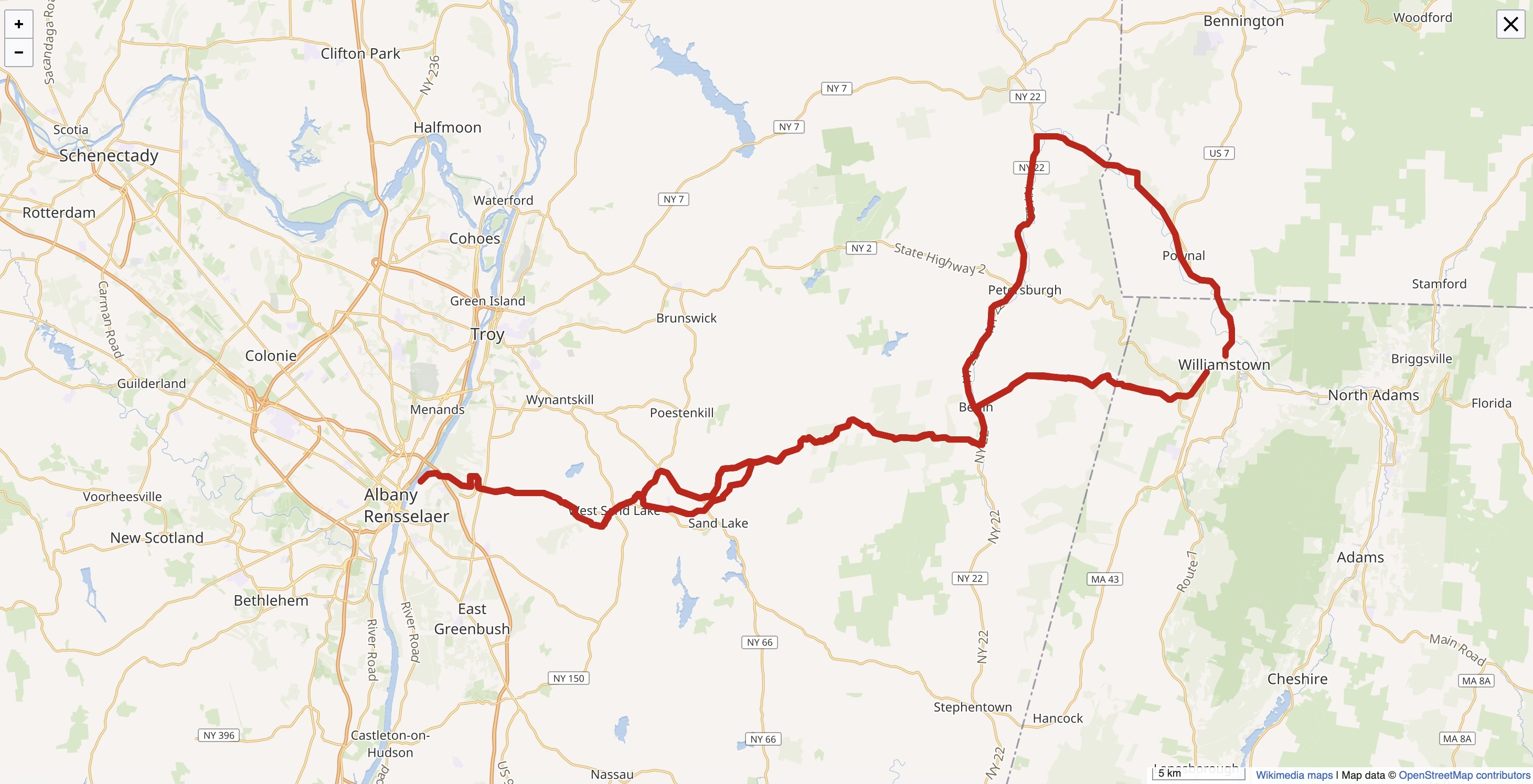
Albany Road as seen on Wikimedia Maps
What has been the most challenging part of this current project?
I think end dates. Usually, you can get close to a start date based on charters and other records. Figuring out when something was abandoned, or when its status downgraded, can be pretty difficult. Sometimes the statements don’t line up. For example, the 1999 Albany Road paper casually drops a line about turnpikes only lasting about 20 years. The Eastern Turnpike was chartered in 1799 to replace the Albany Road, and sold its western end to the Albany to Sand Lake Plank Road Company in 1849 - so obviously there was enough left of the Eastern Turnpike 50 years later to actually sell part of the road. That’s quite a bit longer than 20 years.
Can you talk a bit about how you are documenting the Albany Road across OHM and Wikipedia in parallel? How do these two platforms interact with each other?
It’s been possible for quite a long time for OSM and OHM to include Wikipedia and Wikidata tags, and it’s pretty easy to go into Wikidata and put in a link to a Relation. Wikidata is also pretty okay with people adding new Wikidata items as long as they are identifiers of real things (for some value of “real”). So wikidata can be approached as a universal identifier… I think there are some positive side effects that flow from this. In particular, my draft Wikipedia page for the Albany Road is going to be very thoroughly documented with detailed, concrete citations. Documentation is critical to getting through the review process, and it makes my work better.
Matthew Anderson is mapping Route 66
Provide an overview of your project mapping Route 66.
I had previously done a very deep research effort into Route 66 through Arizona for a Wikipedia article… Since I already enjoyed mapping on OSM-based platforms and knew where to find the necessary sourcing for the Arizona section of Route 66, I decided to take on the project of mapping Route 66 and I-40 through northern Arizona, wanting to help get the route closer to 100 percent completion. There really is no outline or set plan; it’s an on-and-off personal project I tackle in different ways and different methods, depending on what needs to be done and if I have the energy or attention span to do.
What types of sources do you reference when mapping historic roadways?
I use historic maps from the David Rumsey Map Collection, official state highway maps of Arizona bought off eBay or provided by AARoads, and the Arizona Memory Project. I access historic state highway logs and construction documents offered on the Arizona Memory Project and the ADOT website, and I use sources provided by other Route 66 history buffs when primary sourcing isn’t available. I also use HistoricAerials.com, which provides a great abundance of USGS topographic maps and aerial photos, especially in Arizona. In terms of ADOT documents, they usually provide a right of way blueprint of the highway, which can be matched up with a specific year on older ADOT State Highway Logs.
What’s been the most rewarding aspect of either mapping Route 66 or historic mapping in general?
I like seeing the entire history of the highway take shape and seeing how the road evolved. Especially when it’s a little-known or previously unknown section to other highway aficionados. I’ve also traveled Route 66 from end to end three times, and it’s fun to look at what I just mapped and what I learned from it, and be able to say, “Hey, I remember that section, and now I know the story behind it!” It gives a more personalized connection to the old highway.
Are there decades or particular periods of time you find the most enjoyable or interesting to map? Why?
I enjoy the chronology of the Colorado River crossing. Everyone’s familiar with the famous Old Trails Bridge built in 1916, the one that the Joad family drives across in The Grapes of Wrath. But the Red Rock Bridge was really fascinating to me, and in my opinion, more interesting than the Old Trails Bridge. It was a gorgeous steel truss bridge. The Red Rock Bridge was originally built for the Santa Fe Railroad in 1890, and was what ultimately allowed the Santa Fe to reach California.
In 1945, a larger bridge was built further upstream that could carry two parallel rail lines instead of only one, making the Red Rock obsolete. At the same time, the old road grades and hairpin curves on Route 66’s original alignment were getting too dangerous. And since the Santa Fe Railroad had moved the tracks to a new bridge and left the perfectly usable Red Rock Bridge abandoned, with much safer curves and grades along the old railroad bed, California and Arizona saw an opportunity, rebuilding the bridge and its old rail approaches. In 1947, it reopened as the new Route 66. It was finally replaced in 1966 by the I-40 crossing, and despite its historical significance, it was demolished in 1976. There’s no evidence remaining of its existence today, except for an old piece of Route 66 on the old California side of the bridge, which now dead-ends at the cliff above the river. The builder’s plate is preserved at a museum in Needles. Nothing remains in Arizona.
Lastly, I’d say it’s interesting to see how Route 66 was replaced by or evolved into I-40, and how much time and effort it really took to build that Interstate. When I say evolved, I mean that in a literal sense. Most of I-40 is old Route 66, just rebuilt into a freeway with a new set of lanes next to the original roadbed. It’s a melancholy period for obvious reasons, but it gives you a real appreciation for the unsung monumental achievement the Interstate Highway System really is.
Here’s how to stay in touch with OpenHistoricalMap and all of the amazing mappers:
-
Join the #openhistoricalmap channel on the OSM US Slack
-
Check out the OHM Forum
-
Get mapping on OpenHistoricalMap!
Thank you to Matthew Anderson, Richard Welty, and Dan Vanderkam for taking the time to share their stories for this blog post, and for contributing to OpenHistoricalMap. Some interview responses have been edited for length and clarity.
OpenHistoricalMap is a Charter Project of OpenStreetMap US, meaning all donations to OHM are tax-deductible.