Looking to update attributes for trails in OpenStreetMap? First you will need an OpenStreetMap account. You can sign up for a free account. Learn how to create your account here.
1. Identify an official source for the trail you’re looking to improve.
In general, look for city, state, and federal agencies that publish public maps for trail use. Land Trusts and other non-government land managers may also be appropriate sources. For example, here are a few resources mappers have used as official references:
- National Park Service – Bryce Canyon NP Trails
- Chelan-Douglas Land Trust – Wenatchee Foothills Trails
There are a lot of resources out there! Therefore, we also recommend reaching out to the trail operator/land manager to identify the most up-to-date trail map to reference.
An ideal resource will have information such as:
- Trail Names
- Trail Access & Use: Which trails are open? Which trails have access and use restrictions? (i.e. horseback only, closed in winter, dogs not allowed)
- Trail Operator: What is the ownership/operator of the land the trail is on? (i.e. National Park Service, a local land trust)
2. Locate the Trail in OpenStreetMap for Editing
Navigate to OpenStreetMap.org and log in with you OpenStreetMap Account. Zoom or search for the location of the trail you want to update.
Once zoomed in close enough, the “Edit” button will become clickable. This will take you to the iD Editor. Click on trail.
On the left, an information panel will appear with the option to add or modify attributes of a trail. In OpenStreetMap, we refer to these attributes as “tags”.
If you’re interested in learning more about tagging in OpenStreetMap and how tagging decisions are made, we recommend these resources:
3. Update, Add, or Modify Trail Attributes
Using your official reference, update or add tags to the trail in OpenStreetMap. Our goal is for all trails in OpenStreetMap to be tagged with, at minimum, the following information:
- Trail Name
- Trail Operator
- Access Restrictions & Allowed Use
- Informal / Formal
If the trail is…
An official trail please update the trail with the following tags:
highway=pathname=[Name of Trail]operator=*and/oroperator:wikidata=*to indicate the entity that manages the trail or land- Access tags for allowed modes of travel, such as
foot=designated - Other tags as indicated in hiking and trail markings
A closed trail please update the trail with the following tags:
A. For temporary closures:
highway=pathaccess=no
B. For trails that are permanently decommissioned:
- Consider adding a lifecycle prefix to the
highway=*key, such asclosed:highway=pathorabandoned:highway=pathdepending on the situation.
A social trail, determine the correct social trail situation below:
A. Access to this social trail, or social trails in general, is prohibited by the land owner/manager. (as evidenced by posted signs or markings, or by text on e.g. the official website or visitor maps), please update the trail with the following tags:
highway=pathinformal=yesaccess=no
B. Access to this social trail is not prohibited outright, but is officially discouraged by the land owner/manager. (as evidenced by posted signs or markings, or by text on e.g. the official website or visitor maps), please update the trail with the following tags:
highway=pathinformal=yesaccess=discouraged
C. Access to social trails is not prohibited or discouraged by the land owner/manager, please update the trail with the following tags:
highway=pathinformal=yes
A trail leaving public land for private property where the landowner does not allow access by the general public.
highway=pathaccess=private
There is no trail at this location, but mappers have marked a way via a “bushwhack” and it is unlikely that another mapper would mark a trail here, delete these objects from the database.
There is no trail at this location, however, future mappers might mark a trail here due to factors of topography, geography, or the Strava heatmap, please update the trail with the following tags:
not:highway=pathnote=[Describe why]
You can also use the following tagging chart to determine the appropriate tags:
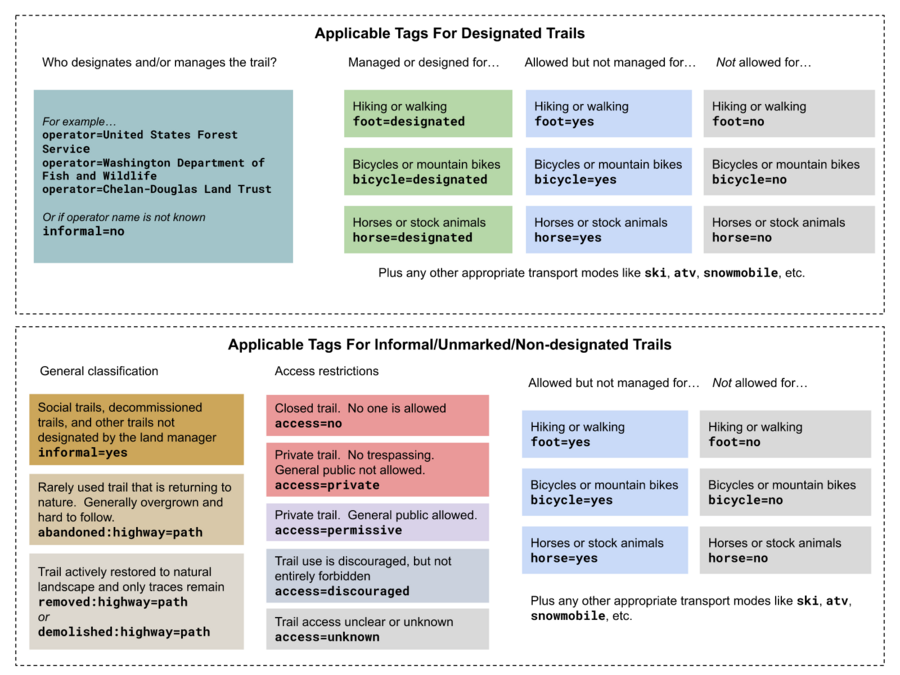 Developed by the OpenStreetMap US Trails Working Group
Example
The Bristlecone Loop Trail at Bryce Canyon National Park was already mapped, but it was missing a few important attributes.
First, up-to-date trail access information was located on the official National Park Service website for the trail here. This page provides a ton of information about the Bristlecone Loop Trail that could be added to OpenStreetMap!
Using this reference, we added information to the trail data in OpenStreetMap. This includes the minimum trail data:
| Trail Attribute | OpenStreetMap Tag |
|---|---|
| Allowed Access | foot=designated, motor_vehicle=no, bicycle=no, dog=no |
| Trail Name | name=Bristlecone Loop Trail |
| Trail Operator | operator=National Park Service |
| Informal/Formal | informal=no |
In addition to these minimum tags, we may also add information such as trail width.
More information on other tags (or attributes) that can be added to trails in OpenStreetMap can be found here